We have completed the NCERT/CBSE Solutions chapter-wise for Class 9 Social Science Chapter 1 India size and location with Answers by expert subject teacher for latest syllabus and examination. Prepare effectively for the exam taking the help of the Class 9 Social Science NCERT Solutions PDF free of cost from here. Students also can take a free NCERT Solutions of India size and location. Each question has right answer Solved by Expert Teacher. Download the Social Science NCERT Solutions with Answers for Class 9 Social Science Pdf and prepare to help students understand the concept very well.
NCERT Solutions for Class 9 Social Science Geography Chapter wise
Page No. 2
Find Out
Q1. Why 82°30’E has been selected as the Standard Meridian of India?
Answer: 82°30′ E has been selected as the Standard Meridian of India because it is situated in the centre of all longitudes and latitudes in which our country is located.
Q2. Why is the difference between the durations of day and night hardly felt at Kanyakumari but not so in Kashmir?
Answer: As equator receivers direct sunlight, the duration between day and night would hardly be felt at Kanyakumari, on the other hand, Kashmir is at 37°N latitude, which means that it is 37 degrees away from the equator or it is 37 degrees away from the area which receives direct sunlight.
Find Out
Q1. The number of Union Territories along the western and eastern coasts.
Answer: Union Territories on the western coast of India are — Diu and Daman, Dadra and Nagar Haveli, Mahe (Pondicherry) and Lakshadweep.
Union Territories on the eastern coast of India are — Pondicherry and Andaman and Nicobar Islands.
Q2. Area-wise which is the smallest and which is the largest state?
Answer: Largest Sate: Rajasthan
Smallest State: Goa
Q3. The states which do not have an international border or lie on the coast.
Answer: Haryana, Madhya Pradesh, Chhattisgarh, Jharkhand, Telangana.
Q4. Classify the states into four groups each having common frontiers with
(i) Pakistan (ii) China (iii) Myanmar and (iv) Bangladesh.
Answer: (i) States having common frontiers with Pakistan are Jammu and Kashmir, Punjab, Rajasthan, Gujarat.
(ii) States having common frontiers with China are Jammu and Kashmir, Himachal Pradesh,
Uttarakhand, Sikkim and Arunachal Pradesh.
(iii) States having common frontiers with Myanmar are Arunachal Pradesh, Nagaland, Manipur, Mizoram.
(iv) States having common frontiers with Bangladesh are Meghalaya, Assam. West Bengal, Tripura.
Page No: 6
Excercise
Q1. Choose the right answer from the four alternatives given below :
(i) The Tropic of Cancer does not pass through:
(a) Rajasthan
(b) Chhattisgarh
(c) Odisha
(d) Tripura
Answer: Odisha
(ii) The eastern-most longitude of India is:
(a) 97°25′E
(b) 68°7′E
(c) 77°6′E
(d) 82°32′E
Answer: 97°25′E
(iii) Uttarakhand, Uttar Pradesh, Bihar, West Bengal and Sikkim have common frontiers with :
(a) China
(b) Bhutan
(c) Nepal
(d) Myanmar
Answer: Nepal
(iv) If you intend to visit the island Kavaratti during your summer vacations, which one of the following Union Territory of India you will be going to?
(a) Pondicherry
(b) Lakshadweep
(c) Andaman and Nicobar
(d) Diu and Daman
Answer: Lakshadweep
(v) My friend hails from a country which does not share land boundary with India. Identify the country.
(a) Bhutan
(b) Tajikistan
(c) Myanmar
(d) Nepal
Answer: Tajikistan
Q2. Answer the following questions briefly.
(i) Name the group of islands lying in the Arabian Sea.
Answer: India lies in the Northern hemisphere, with the mainland extending between latitudes 8°4’N and 37°6’N and longitudes 68°7’E and 97°25’E. The Tropic of Cancer (23° 30’N) divides the country into almost two equal parts, where the Lakshadweep islands lie in the Arabian Sea to the south-west of the mainland, and the Andaman and Nicobar islands lie in the Bay of Bengal to the south-east of the mainland.
(ii) Name the countries which are larger than India.
Answer: Russia, Canada, China, USA, Brazil and Australia
(iii) Which island group of India lies to its south-east?
Answer: Andaman and Nicobar island group lie to the south-east of India
(iv) Which island countries are our southern neighbours?
Answer: Sri Lanka and Maldives are the two island countries that are the southern neighbours of India.
Q3. The sun rises two hours earlier in Arunachal Pradesh as compared to Gujarat in the west but the watches show the same time. How does this happen?
Answer: From Gujarat to Arunachal Pradesh, there is a time lag of two hours, but the watches show the same time because the time along the Standard Meridian of India (82° 30’E) passing through Mirzapur in Uttar Pradesh is taken as the standard time for the whole country. Because the same standard time for the whole country has been adopted, the watches show the same time in Arunachal Pradesh, Gujarat, and in all parts of the country
Q4. The central location of India at the head of the Indian Ocean is considered of great significance. Why?
Answer: The Indian landmass has a central location between the East and the West Asia. India is a southward extension of the Asian Continent. The trans Indian Ocean routes which connect the countries of Europe in the West and the countries of East Asia provide a strategic central location to India.
The Deccan Peninsula protrudes into the Indian Ocean, which help India to establish close contact with West Asia, Africa and Europe from the western coast and with Southeast and East Asia from the eastern coast.
No other country has a long coastline on the Indian Ocean as India has and indeed, it is India’s eminent position in the Indian Ocean which justifies the naming of an Ocean after it.
Map Skills
Q1. Identify the following with the help of map reading.
(i) The island groups of India lying in the Arabian Sea and the Bay of Bengal.
(ii) The countries constituting Indian Subcontinent.
(iv) The states through which the Tropic of Cancer passes.
(iv) The northernmost latitude in degrees.
(v) The southernmost latitude of the Indian mainland in degrees.
(vi) The eastern and the western most longitudes in degrees.
(vii) The place situated on the three seas.
(viii)The strait separating Sri Lanka and India.
(ix) The Union Territories of India.
Answer:
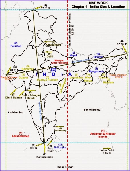
(i) Lakshadweep
(ii) Countries which make the Indian subcontinent are Pakistan in the north-west, India at the core, Nepal in the north, Bhutan in the north-east and Bangladesh in the east.
(iii) Tropic of Cancer passes through the states of Gujarat, Rajasthan, Madhya Pradesh, Chhattisgarh, Jharkhand, West Bengal, Tripura and Mizoram.
(iv) 37°6′ N
(v) 8°4′ N
(vi) Western – 68°7′ E, Eastern – 97°25′ E
(vii) Kanyakumari
(viii) The Palk Strait.
(ix) Andaman and Nicobar Islands, Chandigarh, Dadra and Nagar Haveli, Daman and Diu, Delhi, Lakshadweep, Puducherry (Pondicherry).
We Think the given NCERT Solutions for class 9 Social Science book Chapter 1 India size and location with Answers Pdf free download will assist you. If you’ve got any queries regarding CBSE Class 9 Social Science India size and location NCERT Solutions with Answers, drop a comment below and that we will come back to you soons.