
We have completed the NCERT/CBSE Solutions chapter-wise for Class 9 Social Science Chapter 2 Physical Features of India with Answers by expert subject teacher for latest syllabus and examination. Prepare effectively for the exam taking the help of the Class 9 Social Science NCERT Solutions PDF free of cost from here. Students also can take a free NCERT Solutions of Physical Features of India. Each question has right answer Solved by Expert Teacher. Download the Social Science NCERT Solutions with Answers for Class 9 Social Science Pdf and prepare to help students understand the concept very well.
NCERT Solutions for Class 9 Social Science Chapter wise
Page No. 15
Excercise
Q1. Choose the right answer from the four alternatives given below :
(i) A landmass bounded by sea on three sides is referred to as
(a) Coast
(b) Island
(c) Peninsula
(d) None of the above.
Answer: (c) Peninsula
(ii) Mountain ranges in the eastern part of India forming its boundaries with Myanmar
are collectively called :
(a) Himachal
(b) Uttaranchal
(c) Purvachal
(d) None of the above
Answer: (c) Purvachal
(iii) The western coastal strip south of Goa is referred to as
(a) Coromandel
(b) Konkan
(c) Kannad
(d) Northern Circar
Answer: (c) Kannad
(iv) The highest peak in the Eastern Ghats is
(a) Anai Mudi
(b) Kanchenjunga
(c) Mahendragiri
(d) Khasi
Answer: (c) Mahendragiri
Q2. Answer the following questions briefly:
(i) What are tectonic plates?
Answer: Large fragments of the Earth’s crust and upper mantle separated due to the convectional currents are called tectonic plates.
(ii) Which continents of today were parts of the Gondwana land?
Answer: South America, South Africa, part of Asia (India, Arabia, Malaya), Australia and Antarctica continents were parts of the Gondwana land.
(iii) What is bhabar?
Answer: The northern plains are generally described as flatlands, with no variations in its relief. But, It is not true. These vast plains also have diverse relief features. According to the variations in relief features, the Northern plains can be divided into four regions. The rivers, after descending from the mountains deposit pebbles in a narrow belt of about 8 to 16 km in width lying parallel to the slopes of the Shiwaliks. This region is known as bhabar.
(iv) Name the three major divisions of the Himalayas from north to south.
Answer: The three major divisions of the Himalayas are:
1) The Great or the Inner Himalayas or the Himadri
2) The Middle Himalayas or the Himachal
3) The Outer Himalayas or the Shivaliks
(v) Which plateau lies between the Aravali and the Vindhyan ranges?
Answer: Malwa plateau lies between the Aravali and the Vindhyan range.
(vi) Name the island group of India having coral origin.
Answer: Lakshadweep Islands are composed of small coral islands.
Q3. Distinguish between
(i) Converging and Diverging Tectonic Plates.
Answer:
| Converging tectonic plates | Diverging tectonic plates |
| 1) When tectonic plates move towards each other, they are called converging plates. 2) In the event of two plates coming together they may either collide and crumble or one may slide under the other. 3) They cause folds. | 1) When tectonic plates move away from each other, they are called diverging plates. 2) In the event of two plates moving away from each other they do not collide or crumble. 3) They cause fractures in the crust. |
(ii) Bhangar and Khadar
Answer:
| Bhangar | Khadar |
| 1) It is old alluvial soil. 2) It is found in northern plains. 3) It has a terrace-like feature and is less fertile. | 1) It is the new alluvium. 2) It is found in flood plains. 3) It is more fertile than the Bhangar. |
(iii) Western Ghats and Eastern Ghats
Answer:
| The Western Ghats | The Eastern Ghats |
| 1) Lies parallel to the Western Coast. 2) They are continuous and can be crossed through passes only. 3) The Western Ghats’ average elevation is 900 – 1600 metres. | 1) Lies parallel to the Eastern Coast. 2) They are discontinuous and irregular. 3) The Eastern Ghats are dissected by rivers flowing into the Bay of Bengal. |
Q4. Describe how the Himalayas were formed.
Answer: According to the Theory of Plate Tectonics, the Earth’s crust was initially a single, giant super-continent called Pangea. Gradually, Pangea began to split into a number of pieces due to convectional currents and formed Angaraland and Gondwanaland. Angaraland is the Eurasian land mass and Gondwanaland included India, Australia, S. Africa and S. America as one single land mass. The Indo-Australian plate separated from the Gondwana land due to convectional currents and drifted towards north. Due to this collision, the sedimentary rocks which were accumulated in the geosyncline known as the Tethys were folded to form the mountain system of western Asia and Himalaya.
Q5. Which are the major physiographic divisions of India? Contrast the relief of the Himalayan region with that of the Peninsular Plateau.
Answer: The major physiographic divisions of India are:
- The Himalayan Mountains
- The Northern Plains
- The Peninsular Plateau
- The Indian Desert
- The Coastal Plains
- The Islands
Q6. Give an account of the Northern Plains of India.
Answer: The Himalayan upliftment out of the Tethys Sea and the subsidence of the northern flank of the Peninsular Plateau resulted in the formation of a large basin. Gradually, the rivers flowing from the mountains in the north and the peninsular plateau in the south filled up this depression with deposits of sediments. This led to the formation of the Northern Plains of India.
The formation of the Northern Plains owes largely to the interplay of three major river systems, namely − the Indus, the Ganga and the Brahmaputra along with their tributaries. This physiographic division spreads over an area of 7 lakh square kilometres, and is 2,400 kilometres long and 320 kilometres broad. It is a densely populated region. The rich soil cover, adequate water supply and favourable climate make the region agriculturally very productive.
The Northern Plains are broadly divided into three sections.
The Punjab Plains −Western part of the Northern Plains; formed by the Indus and its tributaries
The Ganga Plains − Largest part of the Northern Plains; extends between Ghaggar and Teesta rivers
The Brahmaputra Plains − Eastern part of the Northern Plains; formed by the Brahmaputra and its tributaries
According to the variations in relief features, the Northern Plains are divided into four regions.
Bhabar − Narrow belt of pebbles lying parallel to the slopes of Shiwaliks
Terai − Wet, swampy, marshy region south of the bhabar belt
Bhangar − Terrace-like feature composed of older alluvium, lying above the flood plains
Khadar − Newer, younger deposits of the flood plains
Q7. Write short notes on the following.
(i) The Indian Desert
Answer: The Indian desert lies towards the western margins of the Aravali Hills. It is an undulating sandy plain covered with sand dunes called barchans. This region receives very low rainfall below 150 mm per year. It has arid climate with low vegetation cover. Streams appear during the rainy season. Soon after they disappear into the sand as they do not have enough water to reach the sea. Luni is the only large river in this region.
(ii) The Central Highlands
Answer: The parts of the peninsular plateau which are found in the north of the River Narmada and generally covers a major portion of the Malwa plateau is known as the Central Highlands. The rivers which drain this region flow from southwest to northeast, due to their slope. The Central Highlands are wider in the western side but narrow down towards the east. In Madhya Pradesh, Uttar Pradesh and Chhattisgarh, they are known as Bundelkhand and Baghelkhad. The Chotanagpur plateau is in the extreme east of the Central Highlands with the the Damodar River flowing through it.
(iii) The Island groups of India
Answer: India has two groups of islands. The Lakshadweep Islands lie in the Arabian Sea, to the southwest of the mainland. The Andaman and Nicobar Islands lie in the Bay of Bengal, to the southeast of the mainland.
Lakshadweep is composed of small coral islands, covering a small area of 32 square kilometres. Kavaratti Island is its administrative headquarters. The Andaman and Nicobar Islands are bigger in size and are more numerous and scattered. The entire group of islands is divided into Andaman (in the north) and Nicobar (in the south).
Both these island groups are rich in flora and fauna, and are of great strategic importance to the country.
Map Skills
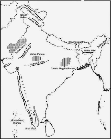
Q1. On an outline map of India show the following.
(i)Mountain and hill ranges – the Karakoram, the Zaskar, the Patkai Bum, the Jaintia, the Vindhya range, the Aravali, and the Cardamom hills.
(ii) Peaks – K2, Kanchenjunga, Nanga Parbat and the Anai Mudi.
(iii) Plateaus, Chotanagpur and Malwa
(iv) The Indian Desert, Western Ghats, Lakshadweep Islands
Answer:
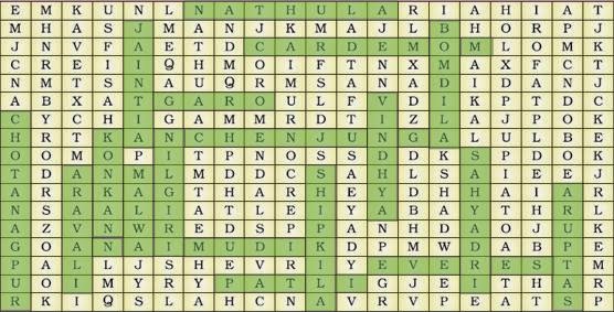
Q2. Locate the peaks, passes, ranges, plateaus, hills, and duns hidden in the puzzle.Try to find where these features are located. You may start your search horizontally, vertically or diagonally.
Answer:
We Think the given NCERT Solutions for class 9 Social Science book Chapter 2 Physical Features of India with Answers Pdf free download will assist you. If you’ve got any queries regarding CBSE Class 9 Social Science Physical Features of India NCERT Solutions with Answers, drop a comment below and that we will come back to you soons.