
We have completed the NCERT/CBSE Solutions chapter-wise for Class 9 Social Science Chapter 3 Drainage with Answers by expert subject teacher for latest syllabus and examination. Prepare effectively for the exam taking the help of the Class 9 Social Science NCERT Solutions PDF free of cost from here. Students also can take a free NCERT Solutions of Drainage. Each question has right answer Solved by Expert Teacher. Download the Social Science NCERT Solutions with Answers for Class 9 Social Science Pdf and prepare to help students understand the concept very well.
NCERT Solutions for Class 9 Social Science Chapter wise
Page No. 23
Exercise
Q1. Choose the right answer from the four alternatives given below:
(i) Which one of the following describes the drainage patterns resembling the branches of a tree?
(a) Radial
(b) Dendritic
(c) Centrifugal
(d) Trellis
Answer: (b) Dendritic
(ii) In which of the following States is the Wular Lake located?
(a) Rajasthan
(b) Uttar Pradesh
(c) Punjab
(d) Jammu and Kashmir
Answer: (d) Jammu and Kashmir
(iii) The river Narmada has its source at:
(a) Satpura
(b) Brahmagir
(c) Amarkantak
(d) Slopes of the Western Ghats
Answer: (c) Amarkantak
(iv) Which one of the following lakes is a salt water lake?
(a) Sambhar
(b) Dal
(c) Wular
(d) Gobind Sagar
Answer: (a) Sambhar
(v) Which one of the following is the longest river of the Peninsular India?
(a) Narmada
(b) Krishna
(c) Godavari
(d) Mahanadi
Answer: (c) Godavari
(vi) Which among the following rivers flows through a rift valley?
(a) Damodar
(b) Tungabhadra
(c) Krishna
(d) Tapi
Answer: (d) Tapi
Q2. Answer the following questions briefly.
(i) What is meant by a water divide? Give an example.
Answer: Any upland or a mountain separating two adjoining drainage basins is known as water divide. An example of water divide is the Western Ghats.
(ii) Which is the largest river basin in India?
Answer: Ganga River basin is the largest river basin in India.
(iii) Where do the rivers Indus and Ganga have their origin?
Answer: Indus river origin – Near Manasarovar Lake, Tibet
Ganga River origin – Gangotri glacier in Uttaranchal
(iv) Name two headstreams of the Ganga. Where do they to form the Ganga?
Answer: Alaknanda and Bhagirathi are the two headstreams of the Ganga. They both meet to form the Ganga at Devprayag.
(v) Why does Brahmaputra in the Tibetan part have less silt despite a longer course?
Answer: The Brahmaputra in its Tibetan part carries a smaller volume of water and less silt as it is a
cold and dry area.
(vi) Which two peninsular rivers flow through troughs? What features do they form while entering the sea?
Answer: The two rivers that flow through troughs are Narmada and Tapi. They form estuaries while
entering the sea.
(vii) State some economic benefits of rivers and lakes.
Answer: Rivers have been of fundamental importance throughout human history. Water from rivers is a basic natural resource, essential for various human activities. Therefore, riverbanks have attracted settlers from ancient times. Using rivers for irrigation, navigation and hydropower generation is of special significance — particularly to a country like India, where agriculture is the major source of livelihood of the majority of its population.
Q3. Below are given names of a few lakes of India. Group those under two categories – natural and created by human beings.
(a) Wular (b) Dal (c) Nainital (d) Bhimtal (e) Gobind Sagar (f) Loktak (g) Barapani (h) Chilika (i) Sambhar (j) Rana Pratap Sagar (k) Nizam Sagar (l) Pulicat (m) Nagarjuna Sagar (n) Hirakud
Answer: The Natural Lakes are: Wular, Dal, Nainital, Bhimtal, Chilika, Pulicat, Sambhar, Barapani, Loktak. The Lakes created by human beings are: Gobind Sagar, Hirakud, Rana Pratap Sagar, Nagarjuna Sagar, Nizam Sagar.
Q4. Discuss the significant difference between the Himalayan and the Peninsular rivers.
Answer:
| The Himalayan Rivers | The Peninsular Rivers |
| (a)They are perennial rivers. They get water from both the melted snow and of heavy rainfall. (b)They perform an immense erosional activity in the upper course. (c)They have long courses from their source to the mouth. (d)They carry large amount of silt and sand, which is renewed every year by annual floods. Therefore they are good for agriculture. (e)The Ganga, the Indus, the Brahmaputra are major Himalayan rivers. | (a)They are seasonal in nature. They depend on rainfall only. (b)They do not perform any erosional activity in the upper course. (c)They have shorter and shallower course. (d)These river do not carry much silt, there are no major plains. Fertile lands are only found in the small delta areas. (e)The Mahanadi, the Godavari, the Krishna, the Kaveri, the Narmada and the Tapi are major Peninsular rivers. |
Q5. Compare the east-flowing and the west-flowing rivers of the Peninsular Plateau.
Answer:
| East-flowing rivers of the Peninsular Plateau | West-flowing rivers of the Peninsular Plateau |
| 1) Major rivers flowing eastwards: Mahanadi, Godavari, Krishna, Kaveri 2) Flow into the Bay of Bengal 3) Carry greater amount of sediments, so form deltas at their mouths 4) Greater number of tributaries | 1) Only two long rivers flow westwards: Narmada, Tapi 2) Flow into the Arabian Sea 3) Carry lesser amount of sediments, so form estuaries at their mouths 4) Lesser number of tributaries |
Q6. Why are rivers important for the country’s economy?
Answer: Rivers have been of fundamental importance throughout human history. Water from rivers is a basic natural resource, essential for various human activities. Therefore, riverbanks have attracted settlers from ancient times. These settlements have now become big cities. Make a list of cities in your state which are located on the bank of a river. Using rivers for irrigation, navigation, hydropower generation is of special significance — particularly to a country like India, where agriculture is the major source of livelihood for the majority of its population.
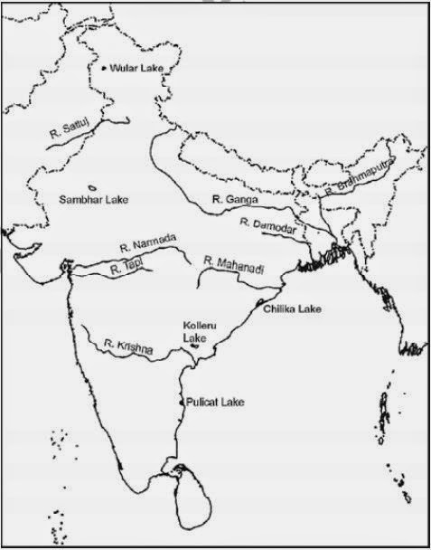
Map Skills
(i) On an outline map of India mark and label the following rivers: Ganga, Satluj, Damodar, Krishna, Narmada, Tapi, Mahanadi, and Brahmaputra.
(ii) On an outline map of India mark and label the following lakes: Chilika, Sambhar, Wular, Pulicat, Kolleru.
Answer:
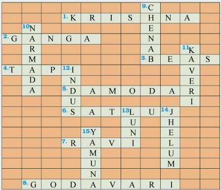
Project/Activity
Across
- Nagarjuna Sagar is a river valley project. Name the river?
- The longest river of India.
- The river which originates from a place known as Beas Kund.
- The river which rises in the Betul district of MP and flows westwards.
- The river which was known as the “Sorrow” if West Bengal.
- The river on which the reservoir for Indira Gandhi canal has been built.
- The river whose source lies near Rohtang Pass.
- The longest river of Peninsular India.
Down
- A tributary of Indus originating from Himachal Pradesh.
- The river flowing through fault, drains into the Arabian Sea.
- A river of South India, which receives rain water both in summer and winter.
- A river which flows through Ladakh, Gilgit and Pakistan.
- A important river of the Indian desert.
- The river which joins Chenab in Pakistan.
- A river which rises at Yamunotri glacier.
Answer:
We Think the given NCERT Solutions for class 9 Social Science book Chapter 3 Drainage with Answers Pdf free download will assist you. If you’ve got any queries regarding CBSE Class 9 Social Science Drainage NCERT Solutions with Answers, drop a comment below and that we will come back to you soons.